BY:SpaceEyeNews.
A Storm So Powerful It Reached Near Space
Super Typhoon Sinlaku was already an unusual storm before scientists discovered its most remarkable feature. In April 2026, the powerful Pacific cyclone rapidly intensified into one of the strongest storms of the season. However, the most surprising development was not taking place at the ocean surface.
Instead, scientists found evidence that Super Typhoon Sinlaku Gravity Waves traveled upward through nearly every layer of Earth’s atmosphere. These waves eventually reached the mesosphere, a region located close to the edge of space.
Satellite observations revealed enormous ripple-like structures spreading outward above the storm. The images offered a rare look at how extreme weather near Earth’s surface can influence regions tens of kilometers above it.
The discovery highlights an important fact. Earth’s atmosphere is a connected system. Events occurring near the ocean can sometimes produce effects that extend almost to space itself.
Super Typhoon Sinlaku Gravity Waves Began With Rapid Intensification
An Unusually Powerful Spring Storm
Super Typhoon Sinlaku formed over the Pacific Ocean in April 2026. Meteorologists quickly noticed that the storm was strengthening at an exceptional rate.
The Japan Meteorological Agency classified Sinlaku as a severe typhoon, the highest category on its intensity scale. This level roughly corresponds to a Category 5 hurricane on the Saffir-Simpson scale.
Such intense storms rarely develop this early in the season within this region. As a result, researchers paid close attention to its evolution.
Massive Energy Released Near the Eye
The rapid strengthening process generated enormous amounts of energy. Warm ocean waters fueled powerful thunderstorms surrounding the eye of the cyclone.
Within these storms, towering cloud structures known as “hot towers” pushed upward through the troposphere. These towers transported heat and moisture to high altitudes.
Scientists have long suspected that such structures can trigger atmospheric gravity waves. Sinlaku provided one of the clearest modern examples of this process.
A Rare Opportunity for Observation
Many tropical cyclones generate atmospheric disturbances. However, researchers do not always capture those disturbances in multiple atmospheric layers at the same time.
In the case of Sinlaku, several satellite instruments monitored the storm during its most active period. This allowed scientists to track the phenomenon from different perspectives.
The result was an unusually complete picture of how Super Typhoon Sinlaku Gravity Waves moved through the atmosphere.
How Super Typhoon Sinlaku Gravity Waves Traveled Toward Space
Understanding Atmospheric Gravity Waves
Atmospheric gravity waves often confuse people because of their name.
These waves are not related to the gravitational waves predicted by Einstein’s theory of relativity. Instead, they are oscillations of air that occur when gravity attempts to restore balance after the atmosphere experiences a disturbance.
A simple comparison helps explain the process.
When a stone falls into a pond, ripples spread outward from the impact point. Atmospheric gravity waves behave in a similar way. A disturbance generates waves that travel through the atmosphere.
The Role of Hot Towers
The key driver behind the phenomenon was the intense convection occurring near the center of Sinlaku.
As warm air rapidly rose, it created powerful updrafts. These updrafts disturbed surrounding atmospheric layers.
Energy then propagated upward through the stratosphere and beyond.
Researchers believe the hot towers served as the launch point for the waves that later appeared in satellite imagery.
Moving Through Multiple Atmospheric Layers
Normally, atmospheric gravity waves weaken as they move upward.
Strong winds often disrupt the waves before they can reach very high altitudes. In most cases, only a portion of the original energy survives.
Sinlaku produced a different outcome.
Scientists found evidence that the waves traveled through the troposphere, crossed the stratosphere, and eventually reached the mesosphere.
That journey carried the effects of the storm to altitudes approaching 80 kilometers above Earth’s surface.
Why The Waves Survived
Researchers identified another important factor.
Spring atmospheric conditions in 2026 produced relatively weak stratospheric winds at the storm’s latitude. Those weaker winds allowed the waves to maintain their structure for a longer period.
As a result, the waves remained visible as they propagated higher into the atmosphere.
This combination of powerful convection and favorable atmospheric conditions created an event that scientists rarely observe.
Satellites Captured Super Typhoon Sinlaku Gravity Waves in Stunning Detail
Rings Visible From Orbit
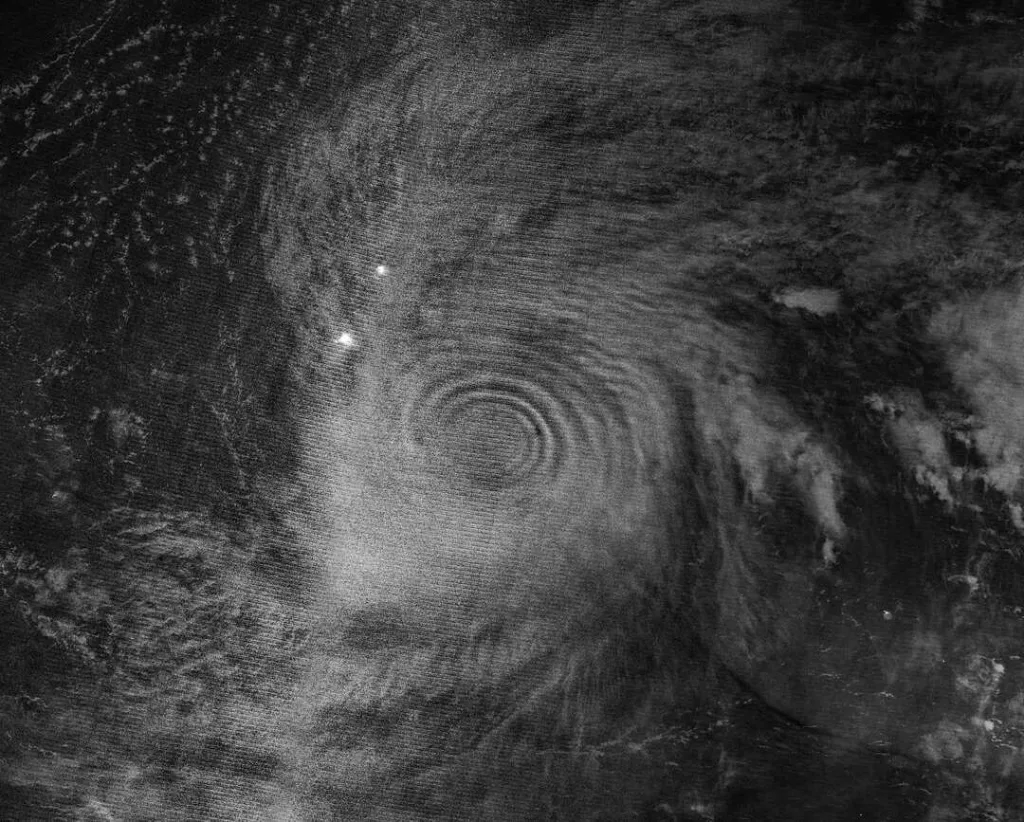
One of the most impressive observations came from the NOAA-20 satellite.
Its Visible Infrared Imaging Radiometer Suite, known as VIIRS, recorded a nighttime image showing large circular wave patterns above the storm.
The waves appeared because of a phenomenon called atmospheric airglow.
During daylight hours, sunlight excites atoms and molecules in the upper atmosphere. At night, these particles release energy as faint light.
The gravity waves altered this glow pattern and made the atmospheric ripples visible from space.
The resulting image showed nearly perfect concentric rings radiating outward from the center of Sinlaku.
A Second Satellite Confirmed The Event
Researchers did not rely on a single observation.
NASA’s Aqua satellite carried the Atmospheric Infrared Sounder, commonly known as AIRS.
This instrument detected thermal signatures associated with the same gravity waves in the stratosphere.
The observations continued on April 13 and April 14, demonstrating that the storm’s atmospheric influence persisted beyond the initial detection.
The agreement between two independent satellite systems strengthened confidence in the findings.
Why Scientists Are Paying Attention
The discovery goes beyond producing impressive imagery.
Researchers believe that atmospheric gravity waves may provide valuable clues about storm behavior.
Monitoring these waves could help meteorologists identify periods of rapid intensification. This remains one of the most difficult forecasting challenges, especially over remote ocean regions.
Additional benefits may emerge as scientists improve their understanding of these atmospheric signals.
Impacts Beyond Weather Forecasting
The significance of Super Typhoon Sinlaku Gravity Waves extends into space science as well.
Previous studies suggest that atmospheric gravity waves can travel even higher than the mesosphere. In some cases, they may influence the ionosphere.
The ionosphere contains electrically charged particles that affect radio signals, satellite communications, and navigation systems.
Large-scale disturbances in this region can interfere with communication networks and GPS accuracy.
By studying events like Sinlaku, researchers gain valuable insight into how weather systems interact with near-space environments.
A Powerful Reminder That Earth’s Atmosphere Is Connected
The discovery of Super Typhoon Sinlaku Gravity Waves revealed far more than an unusual weather event.
Scientists observed a powerful storm transferring energy through nearly the entire atmosphere. The resulting waves traveled from the lower atmosphere to regions close to space and created stunning patterns visible from orbit.
The event also demonstrated the value of modern satellite technology. Multiple spacecraft captured different stages of the phenomenon, allowing researchers to examine the process in unprecedented detail.
Most importantly, Sinlaku showed that Earth’s atmosphere functions as a single interconnected system. Activity near the ocean surface can influence layers tens of kilometers above the planet.
As scientists continue studying atmospheric gravity waves, future observations may improve weather forecasting, enhance communication system resilience, and deepen our understanding of the complex relationship between weather and space.
Main Sources:
NASA Earth Observatory
https://science.nasa.gov/earth/earth-observatory/gravity-waves-from-super-typhoon-sinlaku/
NASA Earth Observatory – Super Typhoon Sinlaku
https://science.nasa.gov/earth/earth-observatory/super-typhoon-sinlaku/
NASA Applied Sciences – Typhoon Sinlaku April 2026
https://appliedsciences.nasa.gov/what-we-do/disasters/disasters-activations/typhoon-sinlaku-april-2026
Universe Magazine
https://universemagazine.com/en/super-typhoon-disturbed-the-atmosphere-almost-to-the-edge-of-space/