
BY:SpaceEyeNews.
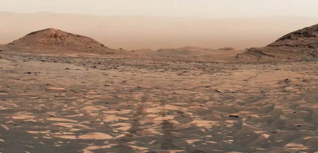
The Curiosity rover Mars climb has reached a striking new milestone. NASA says the rover marked a one-kilometer elevation gain on August 26, 2026. From high on Mount Sharp, it also captured a sweeping look back toward Gale Crater’s floor.
The image shows Curiosity’s tracks fading into the Martian distance. Yet the view represents more than a memorable photograph. Each higher layer gives scientists access to another period of Mars’ environmental history. The climb is therefore both a physical journey and a trip through geological time.
A close-up crop from the panorama above, looking down the side of Mount Sharp. Credit: NASA/JPL-Caltech/MSSS.
Curiosity Rover Mars Climb Reaches One Kilometer
Curiosity has explored the lower slopes of Mount Sharp since 2014. The mountain rises about five kilometers above the floor of Gale Crater. However, the rover’s goal is not to reach its summit.
NASA designed the route around valuable geological targets. Engineers guide Curiosity across slopes, sand, rocks, and exposed bedrock. As a result, the path includes detours, smaller descents, and repeated climbs.
The one-kilometer figure describes an elevation milestone, not the rover’s driving distance. Curiosity did not climb a single vertical wall. Instead, it gained height gradually during years of exploration.
NASA reported in July 2026 that Curiosity had driven more than 37 kilometers. That update also listed about 1.35 kilometers of accumulated elevation gain across the rover’s winding route. The new one-kilometer milestone marks its broader rise up Mount Sharp.
A New Mars Panorama From Valle Grande
Curiosity recorded the panorama on August 1 and 2, 2026. Those dates were sols 4,972 and 4,973 of the mission.
The rover captured the scene from a broad valley called Valle Grande. Its Mast Camera, or Mastcam, collected 323 separate images. NASA’s imaging team combined them into one wide mosaic.
The team adjusted the colors to match lighting as human eyes would perceive it under conditions on Earth. Therefore, the panorama is processed scientific imagery rather than an untouched snapshot.
Curiosity’s tracks appear in a central part of the image. They extend across the rocky terrain and disappear into the distance. Viewers can also see Mount Sharp’s slopes, Gale Crater’s floor, and its northern rim. Dust in the summer atmosphere softens the far horizon.
The view comes from Curiosity’s highest position so far. However, NASA does not describe it as exactly what an astronaut would see.
Why the Curiosity Rover Mars Climb Matters
Mount Sharp works like a layered archive. Its rocks formed during different periods of ancient Martian history. In general, Curiosity reaches younger geological material as it moves higher.
This arrangement allows researchers to compare changing environments within one extended record. Lower areas contain clay-rich rocks and deposits linked to long-lasting lakes. Higher regions include sulfate-bearing material associated with drier conditions.
Reading Mars’ Changing Climate
The broad pattern suggests that Gale Crater shifted from wetter conditions toward a much drier environment. However, Curiosity has shown that this transition was not simple.
Evidence of lakes, streams, groundwater, and later water-related activity appears at different levels. Wetter episodes may have returned after dry intervals. Local conditions also changed as sediments accumulated and erosion reshaped the landscape.
Scientists study the chemistry, texture, and structure of each layer. They want to learn when conditions changed and how long those changes lasted. Every new level can add detail to that timeline.
Valle Grande May Hold a Missing Chapter
Valle Grande is important for another reason. Curiosity’s team is examining a large feature that may represent an “erosional supersurface.”
This surface could mark a break in the rock record. Sediment may have stopped accumulating for a period. Erosion then removed or altered material before deposition began again.
Wind could have produced some of that erosion. Flowing water may also have contributed. Mission images show patterns that resemble wind-shaped features. Scientists have also noticed lens-shaped deposits that may have formed through water activity.
These interpretations remain under investigation. Researchers need detailed images and chemical measurements before drawing firm conclusions.
Curiosity Examines the Boundary Up Close
Curiosity approached an exposed section called Cerro Paine Grande before climbing above the possible boundary. Mastcam created stereo mosaics of the rock face.
The rover also used MAHLI for close views of fine textures. APXS and ChemCam studied selected targets. Together, these instruments can reveal how the material formed and changed.
After one steep climb, Curiosity stopped at an angle of about 24 degrees. Rover planners still positioned it safely enough to conduct contact science. That operation shows how engineering decisions support geological research.
Fourteen Years of Careful Navigation
Curiosity reached this milestone during its 14th year on Mars. Its long climb has tested its wheels, mobility system, and navigation team.
Engineers must avoid loose sand, sharp rocks, unstable surfaces, and slopes that could cause excessive slipping. They also need stable positions for the robotic arm. Every route must balance safety with access to valuable targets.
The rover has continued working despite wheel damage and earlier drilling problems. Engineers changed drilling procedures after a motor issue and kept the science program moving. This adaptability made the one-kilometer ascent possible.
What Curiosity Will Explore Next
Curiosity remains active on Mount Sharp. It continues examining the sulfate- and carbonate-bearing region while moving toward the Yardang unit.
The rover will compare rock chemistry, colors, textures, and sedimentary structures across new layers. It will also monitor dust and other features of the current Martian environment.
The milestone is not a final destination. Nor does it confirm one dramatic new discovery. Instead, it opens access to evidence that can refine the history of water and climate inside Gale Crater.
Conclusion
The Curiosity rover Mars climb has produced an extraordinary view of the route behind it. More importantly, the ascent has carried the rover through a deep record of environmental change.
Its tracks show how far the mission has traveled. The rocks ahead may reveal how Mars moved between wetter periods and the dry world we see today. One kilometer upward has opened another chapter in the planet’s history.
Main sources:
- NASA Science — Curiosity Reaches 1-Kilometer Elevation Gain
- NASA Science — Rock Climbing Towards the Discontinuity
- NASA Science — Celebrating Our Rover Engineers Past and Present
- NASA JPL — Curiosity Captures a Changing Mars Landscape