
BY:SpaceEyeNews.
Near the volcano Alba Mons, a tongue of rocky terrain reaches down a Martian slope and ends in a cliff. The tallest of these Martian crater cliffs rises 209 meters above its base. From orbit, its surface looks much like the rubble around it. Yet its shape suggests that glacier ice once flowed beneath the rocks, and some ice may still survive there. Across 29 sites, researchers found a recurring clue: the deposits end abruptly on slopes that face the north pole.
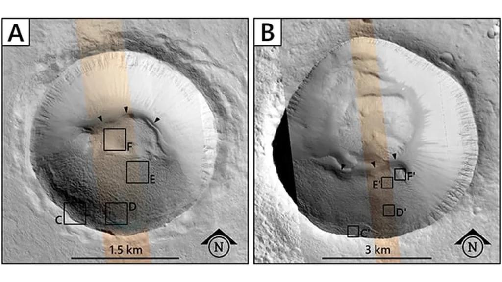
Two craters near Alba Mons on Mars, with arrows marking the curved cliffs at the ends of possible glacier deposits. credit : Le Becq et al., Earth and Planetary Science Letters (2026), via ScienceAlert.
Measuring Martian crater cliffs from orbit
The team examined 738 craters around Alba Mons in the northern hemisphere of Mars. Researchers identified the distinctive deposits in 24 craters and five pits. Some deposits extend as far as three kilometers downhill. From above, their rounded ends resemble broad tongues. Seen in profile, those same ends form slopes that reach up to 42 degrees. The fronts average 127 meters in height, making the tallest example exceptional even among its neighbors.
NASA’s Mars Reconnaissance Orbiter and the European Space Agency’s ExoMars Trace Gas Orbiter supplied the images. Where cameras captured the same ground from two angles, researchers could reconstruct its relief. They traced the change in elevation from the upper surface of a deposit to the foot of its cliff. That distinction matters for interpreting the 209-meter figure. It measures the full height of a landform that includes rocky material. The amount of ice inside remains an open question.
The cameras also captured details at different scales. Broader views show how a deposit fits against a crater wall. In the sharpest images, individual boulders come into view. Matching those views lets researchers follow loose material from the rim toward the floor. In some places, rocks appear to have traveled down the slope and come to rest at its foot.
Clues beneath the rubble
A closer look shows that the cliff faces change texture from top to bottom. Across the upper part, cracks divide relatively smooth ground into polygons. Farther down, the surface grows rougher. Boulders dot the slope, and loose rock gathers in heaps near the floor. On one well-imaged deposit, the cliff cuts across ridges that run along the upper surface. The ridges appear to have continued beyond the present edge.
That missing stretch offers a clue to how the cliffs formed. The researchers propose that ice once carried debris downhill. Later, ice near the front gradually turned directly into water vapor through sublimation. As ice disappeared, the front retreated and loose stones accumulated below. In that reading, the cliff marks an edge that has moved back upslope. Its position today may therefore underestimate how far the glacier once reached into the crater.
An Icelandic glacier offers a closer look
In northern Iceland, a debris-covered glacier called Grænavatnsjökull has a steep front of its own. Aerial images suggest that two layers meet along its face, much as different textures meet on Mars. Fieldwork there could reveal what gives each layer its appearance. Researchers could examine the rocks and ice at close range, then compare their findings with features the orbiters can resolve. One particularly telling detail is whether a change in surface texture also marks a change in the material underneath.
Why ice may have survived near Alba Mons
If regional climate alone determined where ice survived, the deposits should follow a pattern that climate models can reproduce. Instead, many sites fall in places where simulations allow seasonal ice to collect but predict little lasting gain. Ice can arrive during one season and disappear during another. To build a glacier, some of each year’s accumulation must survive long enough for more ice to gather above it.
The orientation of the Martian crater cliffs helps explain that puzzle. In this northern region, a pole-facing slope can shelter ice from direct sunlight. Dust and rock over the ice could also slow its loss to the atmosphere. Two slopes in the same crater can therefore preserve different traces of the same climate. Over time, even a local difference in exposure could help determine which slope retains an icy deposit.
The team traces the likely origin of the deposits to a geologically recent period when Mars tilted farther on its axis. That tilt changed how sunlight reached different latitudes and where water ice could accumulate. The cliff faces may preserve evidence of two stages in that history. Their broad tongues suggest a time when ice could build up and flow. Their shortened fronts point to a later interval when the deposits lost ice.
Buried ice and future crews
For future crews, a promising deposit raises practical questions. How far below the rocky cover does the ice begin? How much rock lies mixed within it? A tall cliff offers little guidance on either point. A thick layer of debris could help ice endure for a long time while also making it harder to reach. The same protective cover that interests climate scientists matters to engineers for a different reason.
NASA already brings several kinds of orbital evidence together through its Subsurface Water Ice Mapping project. Elsewhere on Mars, fresh craters have briefly exposed bright ice beneath the surface, giving scientists a direct check on their maps. At Alba Mons, the evidence comes chiefly from terrain, texture and modeling. These sites give researchers specific places to examine before anyone can estimate how much water a crew might recover.
Where to look for more Martian crater cliffs
The next search can start with an ordinary-looking patch of rubble. Does it form a tongue on a pole-facing slope? Does its upper surface end abruptly above a boulder-strewn base? Finding that combination elsewhere would give researchers a way to test how closely the deposits depend on conditions around Alba Mons. For now, the Martian crater cliffs offer something more specific than a general hint of buried water. They show where to look for the edge of a former glacier, even when rock and dust hide the ice itself.
Main sources:
Original research in Earth and Planetary Science Letters — https://doi.org/10.1016/j.epsl.2026.120444
Research team’s conference paper on the cliff textures and Icelandic comparison — https://www-mars.lmd.jussieu.fr/mtt2025/abstracts/Le-Becq.pdf
NASA on mapping buried water ice — https://www.nasa.gov/solar-system/planets/mars/nasa-is-locating-ice-on-mars-with-this-new-map/
ScienceAlert coverage — https://www.sciencealert.com/scientists-have-discovered-strange-glaciers-with-towering-cliffs-inside-martian-craters
You Might Also Like:
Rare Martian Meteorite Reveals Mars’ Hidden History
Mars Layered Deposits Reveal Ancient Climate Clues
Mars volcanic activity: Strange Gas Hints at Hidden Heat